Parrot has announced that its ANAFI platform is now compatible with SPH Engineering’s professional mission planning software UgCS.
ANAFI users can now enhance professional drone operations and streamline land surveying and mapping processes by accessing the program’s vast range of tools.
“UgCS is one of the most advanced mission planning software for drones. Its unique features make it the perfect tool to complete complex and large-scale mapping projects,” says Jerome Bouvard, Parrot director of Strategic Partnership.
“This partnership will broaden the mapping capabilities and software options available to professional ANAFI users as a whole.”
Software
Software
AeroVironment acquires German ground robotic solutions developer Telerob
AeroVironment has acquired German ground robotic solutions developer Telerob Gesellschaft für Fernhantierungstechnik mbH.
Founded in 1994, Telerob, which is based near Stuttgart, Germany, offers advanced and comprehensive turn-key unmanned ground robotics solutions, including the telemax and tEODor EVO family of UGVs, fully-equipped transport vehicles and training, repair and support services. Some of the dangerous missions that Telerob’s solutions safely and effectively perform include explosive ordinance disposal (EOD), hazardous materials handling (HAZMAT) and chemical, biological, radiological and nuclear (CBRN) threat assessment.

Auterion announces Cynthia Huang as its Vice President of Enterprise Business Development
On Tuesday, Dec. 8, Auterion announced the appointment of Cynthia Huang as the company's Vice President of Enterprise Business Development.
Considered one of the top executives in the drone industry, Huang, who comes from DJI, will lead the go-to-market strategy for Auterion’s suite of enterprise products. Huang will partner with enterprise customers in the utility, oil & gas, telco, and mining industries to provide the customization and flexibility available with Auterion’s platform and fast-growing ecosystem of manufacturers and independent software vendors.
senseFly establishes itself as a leader in BVLOS operations
As beyond visual line of sight (BVLOS) UAS operations are primed to open a range of possibilities in the drone industry, fixed-wing drone solutions provider senseFly has established itself as an early leader in safely and successfully performing these operations.

Weekend Roundup: December 4, 2020
This week (and last) in the Unmanned Systems and Robotics World
Mississippi State University (MSU) engineers in the university’s Raspet Flight Research Laboratory are leading research efforts that could make UAS operational by the U.S. government, as well as civilian aviation, in icy conditions. The U.S. Department of Defense is hoping that the icing system development and technology team being led by MSU will result in lightweight anti-icing systems, which would lead to certification for UAS to operate in forecasted icing conditions. (Mississippi State University)

FLIR Systems acquires small UAS manufacturer Altavian
FLIR Systems has acquired Altavian Inc., a Gainesville, Florida-based privately-held manufacturer of small UAS (sUAS) for defense and public safety customers.
Altavian UAS users are provided with decision support and intelligence, surveillance, and reconnaissance (ISR) capability, thanks to Altavian's airframes integrating multiple sensors, including FLIR thermal technology.
Founded in 2011, Altavian designs and manufacturers Group 1 UAS platforms for long or short range operations. Altavian designs both quadcopter and fixed-wing UAS, so its expertise includes aeronautics, avionics, and software. The company’s solutions are engineered around an open system architecture aligned to the needs of government and defense customers.
RE2 Robotics secures patent for invention of fluid rotary joint that can be used in robotic arms
The U.S. Patent and Trademark Office has issued RE2 Robotics a patent for the invention of a fluid rotary joint that is capable of precise positioning while being driven by both fluids and gasses, including water, hydraulic fluid, and air.
According to RE2 Robotics, the patent, “Fluid Rotary Joint and Method of Using the Same,” further adds to its mobile manipulation intellectual property and underwater robotics expertise.
“The issuance of this patent further solidifies RE2’s position as a world-class intelligent mobile manipulation provider,” says Jorgen Pedersen, president and CEO.

Using inertial and position measurements in testing and survey projects – bridging the gap between autonomous vehicle development and survey
OxTS Inertial Navigation Systems are used throughout the world to provide autonomous vehicle testing engineers and surveyors with highly accurate, absolute position and orientation measurements. These measurements help users realize cm-level surveying and testing accuracy, while at the same time increasing repeatability. But how do these two industries dovetail when it comes to using this information? Join NavtechGPS and OxTS as we discuss “Using inertial measurements in testing and survey projects – bridging the INS gap between autonomous vehicle development and survey.”
Speakers:
Paris Austin, Business Manager, Survey & Mapping, OxTS
Franck Boynton, VP and CTO, NavtechGPS
Boeing completes tests of its advanced autonomy technology
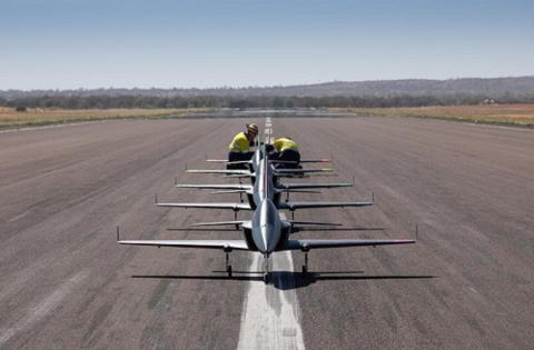
Boeing has announced that it recently completed flight tests with five high-performance surrogate jets operating autonomously in a team at the new Queensland Flight Test Range in Cloncurry, Australia.
The 11-foot aircraft were used to test Boeing’s advanced autonomy technology, including on-board command and control and data sharing capabilities.
“The tests demonstrated our success in applying artificial intelligence algorithms to ‘teach’ the aircraft’s brain to understand what is required of it,” says Emily Hughes, director of Phantom Works International.

Drone Harmony decides to embed its flight mapping solutions with Altitude Angel's market-leading data
Unmanned Traffic Management (UTM) technology provider Altitude Angel has announced that software company Drone Harmony has opted to equip its flight mapping solutions with Altitude Angel’s market-leading data.
Drone Harmony is developing a data capture platform that enables enterprises to capture quality data of infrastructure assets. According to Altitude Angel, this addresses the main hurdle encountered when attempting to tap into digitalization benefits: the lack of complete, quality, and up-to-date digital databases representing the enterprise assets.

