Mapping the Future With WISPR Systems
August 6, 2024 | Dawn Zoldi
 WISPR Systems, headquartered in Batesville, Mississippi, specializes in manufacturing uncrewed aircraft systems (UAS) and delivering turn-key commercial solutions for enterprise and public safety UAS applications, with an emphasis on surveying and mapping. In this exclusive interview, John McArthur, VP of Sales and Marketing at WISPR Systems, discusses the company’s growth from a university project to an innovative leader in the UAS industry.
Dawn: John, tell us about how WISPR Systems began.
John: Our two founders, Conor Ferguson and Austin Ratcliffe, were childhood friends who reunited at Mississippi State University. In 2015, one of their professors needed UAS for payloads to collect data for his tenure project. Conor (whose passion for technology began at the age of six) volunteered to build a quadcopter, a hexacopter and an octocopter, as well as the software for mission planning. And so he did. These initial drones, which are still in use at the university today, quickly gained a reputation for their affordability and reliability. In 2017, after receiving invaluable support from the Mississippi State University Center for Entrepreneurship & Outreach Center and securing initial funding through the university’s Bulldog Angel Network and InnovateMS, Conor and Austin co-founded WISPR Systems.
Dawn: What pitch did the founding members make to investors, in terms of primary market?
John: The answer to this relates to the name of our company. A lot of people hear “WISPR” and think it refers to a quiet UAS, but “WISP” stands for “Wireless Internet Service Provider,” our original target market. The original business model aimed to improve WISP network safety and efficiency by eliminating the need for bucket trucks and by turning a two-person job into a one-person job.
Dawn Zoldi: How has WISPR evolved as a company over time?
John McArthur: When 2020 hit, it disrupted the WISP industry, and WISPR Systems viewed this as a catalyst for change. By 2021, when I joined the company, we pivoted to new markets, including surveying, mapping, inspection and public safety. Our goal was to become the most reliable and user-friendly solution in technical fields that required precise data collection.
Dawn: John, let’s talk about your UAS and start with the Ranger Pro Series.
John: The Ranger Pro Series evolved from our original specialized UAS built for the WISP space, which required a larger frame to support big antennas. Over five years, we modified that frame to add external ports for easy integration of various payloads. Today, the flagship Ranger Pro supports up to 7 pounds of payload, from LiDAR to ground-penetrating radar, magnetometers or methane detection sensors. As new sensors become available, we offer them to our customers to plug-and-play with the Ranger Pro. We continued this high level of versatility in our newer model, the SkyScout.
Dawn: How does the new SkyScout differ from the Ranger Pro?
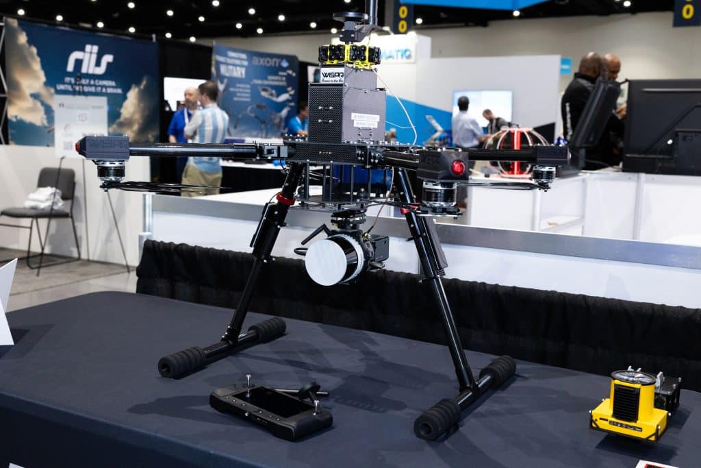
John: The SkyScout is a smaller and more compact version of the Ranger Pro (13x10x4 inches). Unlike the Ranger Pro, which uses external cables to power the gimbals and other components, and which can be prone to field damage, the SkyScout features a quick-attach system developed in collaboration with Gremsey. This system allows power and data to run through a single connection for all camera payloads and alleviates the need for external wires.
Dawn: What markets is SkyScout suitable for?
John: The inspection and public safety fields require a small form factor, affordability and ease of use, which the SkyScout offers. The highly portable Sky Scout has a flight time of 26 to 30 minutes, depending on conditions, and a 25% battery fail-safe for reliability. The setup process is simple, and our smart batteries greatly contribute to its deployment simplicity. We also plan to make SkyScout compatible with new public safety-focused software solutions later this year.
Dawn: Tell us more about your smart batteries.
John: We developed a battery specifically for our system that tracks maintenance cycles, provides battery health data and simplifies management. We created an integrated Battery Management System (BMS) and a single button on top for ease of use. Our goal is to make battery management as simple as possible and to reduce the common issues associated with it.
Dawn: Explain how the SkyScout also is resilient against electromagnetic interference (EMI).
John: During inspections, operators often encounter powerful antennas that can disrupt GPS signals and cause interference, known as EMI. This can potentially lead to issues like the uncrewed aircraft (UA) spiraling out of control and crashing, which we experienced during testing in the early days. As a result, our UAS’ have airplane-grade shielding that absorbs and dissipates EMI, rather than merely reflecting it. We also offer 3D modeling capabilities and can equip our drones with personal communications interference (PCI) scanners and spectrum analyzers for advanced tasks. We even perform interference hunting with our Ranger Pro for customers, which is a highly specialized operation. In the cell phone industry, for example, finding sources of interference can be as simple as tracing a disrupted signal back to a miswired speaker in a church.
Dawn: The ability to have a drone that’s not only resistant to interference but also capable of locating it is impressive. Let’s talk about the advanced navigation and software features of the SkyScout.
John: Our tagline, “Power to the Pro,” reflects our mission to empower customers to achieve their best work as simply as possible. This philosophy drives our decisions regarding which payloads to use, how we develop mission planning software and design system fail-safes. Our collaboration with CubePilot in Australia has been essential in providing high-quality components for our UAS. CubePilot’s technology, combined with our software, enables us to offer robust and high-quality solutions.
Dawn: Tell us a little about the uniqueness of the Gremsy payloads and why you think they are so important and beneficial for the pros using your UAS.
John: Gremsy is arguably one of the best gimbal manufacturers in the world. They’ve recently expanded into sensor manufacturing, pairing Sony and FLIR sensors with their gimbals. As we developed the SkyScout, we approached Gremsy for their expertise. They were already working on some new payloads, such as the Gremsy Vio, an impressive inspection camera designed for industrial applications. For those focusing solely on RGB capabilities, the Gremsy ZiO provides a more economical alternative. We also collaborated with Gremsy on the new Sony ILX LR1 which is powered by a 61-megapixel, full-frame, back-illuminated Exmor R CMOS sensor and the BIONZ XR image processor. As a result of our partnership with Gremsy, we now have a super high-quality UAS with very low vibrations, an easy setup workflow and a great sensor lineup. We’re very proud of this partnership and deeply appreciate Gremsy’s level of collaboration with us to help bring these products to market.
Dawn: Could you tell us about the LiDAR systems you work with, their resolutions and the payloads?
John: We collaborate with various LiDAR companies, such as GeoCue, Phoenix LiDAR Systems, LIDAR USA, and YellowScan, as well as Inertial Labs, who we’ve worked with the longest. We aim to offer different sensors at different price points to cater to our diverse customer base. One of the features we provide is easy integration. Customers simply need to mount and power the unit. For the Ranger Pro, we can carry a whole suite of LiDAR units, including the RIEGL mini-Vux. The first LiDAR system we’ll be integrating into the SkyScout is Inertial Labs’ XT32 M2X, without a camera due to weight limitations.
Dawn: When people think about mapping and surveying, they just think about land, but our planet is covered with a lot of water. Knowing what’s under there is important for a lot of different industries. What sensors do you use for that?
John: The specialty bathymetric sensor integrates with the Ranger Pro, because the payload weighs six pounds and hangs off the UAV and drags through the water. Our partner for this is SPH Engineering out of Latvia. Many people know them as UGCS, which is their software side, but SPH Engineering is the parent company that also sells the hardware. The bathymetry sensor is a dual-frequency echo sounder that essentially performs sonar operations. We also use a radar altimeter to maintain the transducer at the correct depth in the water.
Dawn: Methane detection is a compliance necessity rather than just a nice-to-have feature for some missions. Have you also seen an increasing demand for methane measurement in the industry?
John: Methane detection is gaining traction due to increased environmental regulations. The U.S. Environmental Protection Agency (EPA) uses a satellite network to track plumes from landfills, and if the methane levels exceed the parts per million (ppm) threshold, they can fine the facility up to $10,000 per day for non-compliance. The traditional method to detect methane involves having somebody walk hundreds of acres with a hand sniffer, on a daily basis. We attach a sensor, called the Laser Falcon, to our UAS, which provides qualitative data, rather than quantitative data and to help identify plumes and anomalies more quickly from the air.
Dawn: John, tell us what’s next for WISPR Systems and how can they learn more?
John: For the rest of this year, we’re focusing on launching SkyScout and a couple of new payloads as well as forming more partnerships. In the meantime, we’re easy to find on all social media under WISPR Systems. You can reach me directly at jmcarthur@wisprsystems.com. We also plan to showcase SkyScouts at the Commercial UAV Expo, so if you are going to be in Vegas, let’s arrange a meeting!
Contact WISPR Systems at https://wisprsystems.com/contact-us/Watch John McArthur of WISPR Systems in his recent episode of the Dawn of Autonomy podcast