Reality Capture Insights from Leica Geosystems
January 7, 2025 | Dawn Zoldi
Leica Geosystems’ geospatial technologies and autonomous systems continue to set new standards for safety, efficiency and accuracy in data collection across various sectors. In a recent episode of the Dawn of Autonomy podcast, Michael Harvey, Senior Product Manager for Reality Capture at the company, provided an in-depth look at its suite of complementary devices and integrated software solutions – the BLK ARC, BLK2GO and BLK2FLY – and how they enhance operational capabilities in surveying and mapping, especially in challenging environments.
Background and Role at Leica Geosystems
Dawn Zoldi: Tell us about your background.
Michael Harvey: I have a degree in civil engineering. I originally worked as a land surveyor in Austin for 11 years. Around 1999-2000, I was an early adopter of laser scanning technology. In 2004, I joined Leica Geosystems as part of their sales group, and in 2007, I moved into product marketing
Dawn Zoldi: What is your current role at Leica Geosystems?
Michael Harvey: I am the Senior Product Manager for Reality Capture. I oversee technical, sales, support, and training groups while collaborating closely with customers to drive product improvements.
Overview of Leica Geosystems
Dawn Zoldi: How has Leica Geosystems evolved over time?
Michael Harvey: The company was founded in 1819 as Kern & Company and has deep roots in land surveying. Over the years, it has evolved into a leader in precision measurement and reality capture technology. We’re known for our Swiss precision and high-quality devices, ranging from handheld digital measures to advanced systems used in fixed-wing aircraft for topography mapping.
Reality Capture Lineup & Integration
Dawn Zoldi: Leica Geosystems offers a wide range of reality capture products. Walk us through them. Let’s start with the BLK ARC.
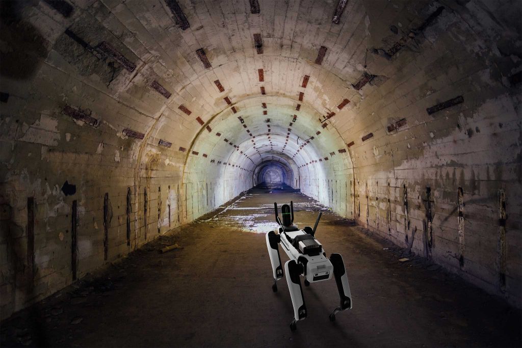
Michael Harvey: The BLK ARC stands for Autonomy Reality Capture. This sensor integrates directly with robots like the Boston Dynamics’ Spot dog. It scans 360 degrees as it moves, feeding lidar information to control the robot’s movement and trajectory. The BLK ARC does not require a battery; it draws power directly from its robotic carrier. Perhaps most importantly, it autonomously operates. It can be programmed for predetermined paths and can also pause to gather detailed scans in a particular location when needed. We purposefully designed the BLK ARC to address markets where sending a person might be unsafe or impractical, such as construction sites during off-hours or in public safety scenarios.
Dawn Zoldi: Tell us about the BLK2GO.
Michael Harvey: The BLK2GO is a lightweight (under 2 lbs.) handheld mobile scanning device that allows users to capture data while walking. Similar to the BLK ARC, it allows users to pause and gather more detailed information as needed. We designed it to be user-friendly. Operators just push a button to start scanning as they walk.
Dawn Zoldi: What’s the difference between the BLK2GO and the BLK ARC?
A: Like the BLK ARC, the BLK2GO can pause and gather more detailed information as needed. The main difference between static scanning and autonomous devices like the BLK2GO and BLK ARC is the addition of trajectory – you’re projecting the point cloud as you move, rather than merging static scans in software.
Dawn Zoldi: What inspired the creation of the BLK2FLY, and how does it work?
A: The BLK2FLY addresses the challenge of capturing data on tall buildings or structures where ground-based scanners create shadows or miss areas. It’s designed to fly close to objects and scan them, complementing ground-based data for a complete dataset. The drone features radar and optical obstacle avoidance, which allows it to navigate around objects. It also has intelligent mission planning, so it can return home for a battery change and resume its mission automatically.
Dawn Zoldi: How do these different devices work together in a multi-modal system?
A: All of our devices can work together seamlessly. For example, you could use the BLK ARC on a robot dog, walk with the BLK2GO handheld scanner, and fly the BLK2FLY drone – all in the same project. The data from these devices can be combined in our Register 360 software or uploaded to our cloud software, RealityCapture Studio, for collaborative work across different locations.
Use Cases Across Industries
Dawn Zoldi: What are some examples of use cases for the BLK suite?
Michael Harvey: We have customers across various segments and industries. Folks use them in construction to compare built structures against design models for accuracy verification. In the energy sector, users capture data in tough environments for infrastructure monitoring. They enable public safety to conduct reconnaissance in potentially dangerous areas without risking personnel. They are ideal for infrastructure inspections, especially in GPS-denied environments, such as to examine tunnels and hard-to-reach areas. Finally, the level of precision that these products offer enables detailed scanning of historical buildings and facades for architectural preservation applications.
Dawn Zoldi: Can you share a real-world example of how folks have used these technologies in any of these various markets?
Michael Harvey: Sure. Turner Construction uses the BLK ARC with the Boston Dynamics Spot Dog, as well as the BLK 2GO regularly on their projects. It really streamlines their ability to capture as-built conditions and continually monitor the progress and quality of their work.
A large oil and gas company uses our devices to capture data in hazardous conditions. While specific details are confidential, our solutions have significantly improved their operational safety and efficiency by enabling precise measurements without risk to personnel.
Customer Support and Training
Dawn Zoldi: How does Leica Geosystems support customers in implementing these technologies?
Michael Harvey: We believe in creating partnerships with our customers, not just selling products. We offer comprehensive training through “Smart Plans.” These include on-site training sessions and monthly online virtual classrooms. We also host an annual Leica Geosystems U event to gather customers for a week of intensive classes and networking opportunities. We also have training facilities on both the East and West coasts of the US where customers can receive hands-on instruction.
Future Outlook & Practical Tips
Dawn Zoldi: What do you see as the future of reality capture and autonomous systems?
Michael Harvey: The future is incredibly exciting. We’re seeing increased integration of AI and machine learning in our systems, allowing for more intelligent data capture and processing. The trend towards autonomy will continue, with robots and drones taking on more complex tasks in surveying and mapping. We’re also focusing on making our systems more user-friendly and accessible to a broader range of professionals beyond traditional surveyors.
Dawn Zoldi: What advice would you give to professionals looking to incorporate reality capture technology into their workflows?
Michael Harvey: Start by identifying your specific needs and challenges. Our team can help you determine which solutions best fit your requirements. Don’t be intimidated by the technology – our training programs are designed to get you up to speed quickly. Also, consider the long-term benefits of investing in high-quality, versatile systems that can grow with your needs.
Learn More
Dawn Zoldi: How can folks learn more about Leica Geosystems?
Michael Harvey: Our website is chock full of all our technologies. You can also always reach out to any one of our expert sales staff. Most of them, if not all of them, are all from the industry.
Dawn Zoldi: How can they reach you?
Michael Harvey: Our contact information is on our website. You can call us or submit a form through https://leica-geosystems.com/en-us/contact-us/sales_support
Key Product Features and Characteristics
 Key features of the BLK ARC sensor:
-
360-degree scanning capability while in motion
-
Provides lidar information to control robot movement and trajectory
-
Draws power directly from the robotic carrier
-
Can be programmed for predetermined paths
-
Ability to pause for more detailed scans in areas of interest
Characteristics of the BLK2GO handheld mobile scanning device:
-
Weighs under 2 pounds
-
Designed for mobile scanning while walking
-
Can pause to gather more detailed information as needed
-
Projects point clouds while moving, allowing for dynamic data collection
-
Ideal for scenarios where setting up a tripod is not feasible
The BLK2FLY autonomous flying laser scanner can:
-
Fly close to objects and scan them
-
Complement ground-based data for a complete dataset
-
Avoid obstacles with its radar and optical obstacle avoidance
-
Provide intelligent mission planning capabilities
-
Operate in GPS-denied environments, including indoors
Various industries use Leica Geosystems’ suite of products including:
-
Construction: Comparing built structures against design models
-
Energy sector: Capturing data in challenging environments
-
Public safety: Reconnaissance in potentially dangerous areas
-
Infrastructure inspection: Examining tunnels and hard-to-reach areas
-
Architectural preservation: Detailed scanning of historical buildings and facades