uAvionix Aims to ‘Connect Everything That Flies’
June 24, 2024 | Dawn Zoldi
uAvionix, renowned for its expertise in communications, navigation and surveillance (CNS) technologies, offers a wide range of safety solutions to enable complex aviation operations among all airspace users in the national airspace system (NAS). In a recent Dawn of Autonomy podcast, Brit Wanick, the company’s Vice President of Marketing, discussed its initiatives to enhance aviation safety and accessibility through the development of compact avionics solutions for both commercial and military crewed and uncrewed aircraft.
Dawn Zoldi: Brit, could you share the origin story of uAvionix?
Brit Wanick: Sure. uAvionix was established around 2015 with the objective of enabling drones to be seen by crewed aircraft using ADS-B technology. However, our initial concept faced regulatory challenges with the Federal Aviation Administration (FAA). So, the team said, “Well, hey, if we can’t make the drones be seen by the crewed aircraft, how about we make the crewed aircraft be seen by the drones?” And boom, we stepped right into the ADS-B mandate and that timing helped launch the company. Since then, uAvionix has expanded in various ways, maintaining a strong focus on rapid innovation, safety and efficiency across all aviation sectors. That includes defense, crewed aviation, uncrewed aviation and even more recently, aviation data-as-a-service to support all of those constituents including airports.
Dawn Zoldi: uAvoinix has a rich history in general aviation. You recently launched a surface situational awareness tool to air traffic control (ATC) towers across United States (U.S.) airports. How does that fit into your larger ecosystem?
Brit Wanick: We are proud to be part of the Surface Awareness Initiative (SAI) with the FAA. We’ve got a deep background in understanding ADS-B, both in terms of broadcasting and receiving signals. So, it was a natural extension as we leveraged that understanding to deliver something to Air Traffic Controllers, essentially at underserved airfields, to help with avoiding incursions. The focus is on helping to prevent runway incursions between aircraft and ground vehicles within the airport’s vicinity. This FlightLine capability, tailored to the SAI can detect cooperative aircraft and ground vehicles transmitting ADS-B Out. This is crucial for enabling drone corridors and operating areas where folks plan to implement drone delivery services or drone as first responder (DFR) programs. The FAA’s rigorous testing and proposal processes have validated our technology, allowing its deployment at control towers. This endorsement enables us to bring these advancements into the uncrewed aviation sector while benefiting crewed aviation. Our aim is to achieve an integrated capability that ensures both safety and efficiency. The opportunity presented by SAI allows us to quickly support controllers and we have the potential to deploy the technology at over 200 airports, although this will take time.

Dawn Zoldi: Could you explain the gap that you filled with FlightLine, particularly for these underserved smaller airports?
Brit Wanick: Sure. The Airport Surface Detection Equipment-Model X (ASDE-X) is an established program that serves larger airports, providing tracking capabilities for both aircraft and ground vehicles. This enterprise-level capability, deployed by the FAA, is operational today to ensure safety at our airports. However, at smaller airports, the tracking is often limited to the air traffic controller in the tower. In these locations, ATCs use available systems, including radar or visual methods and communicate with aircraft to manage the airspace and ensure safety. The SAI system provides an additional level of support by displaying real-time air traffic information from aircraft broadcasting on ADS-B or from ground vehicles equipped with ADS-B transponders. For instance, if Ops One or Ops Two is conducting a foreign object debris (FOD) check on the runway at night, these vehicles can now be tracked on the runway through a vehicle tracking unit which is essentially an ADS-B transmitter installed on the vehicle – a VTU. Our partners like ForeFlight can collect ADS-B traffic data in the cockpit. So, if I am in my Cessna 172 making a night landing and Ops Two is on the runway, I can receive an alert on my iPad indicating the presence of the vehicle on the runway. This enhanced situational awareness represents a significant advancement in safety for operators and pilots. Our technology is particularly beneficial when there is a substantial load on ATCs and airports. With the increasing number of aircraft, including uncrewed aircraft, there is an urgent need for such systems. Given recent reports of potential incursions, the FAA requested our assistance and we were ready to deliver.
Dawn Zoldi: Can FlightLine be used by helicopters?
Brit Wanick: Helicopters can be equipped with ADS-B out, with many utilizing our tailBeacons. Essentially, anything that flies and is capable of generating ADS-B signals on 1090 MHz or 978 MHz (UAT) can be detected by our ground-based receivers and subsequently displayed.
Dawn Zoldi: How is FlightLine different or similar to Traffic Alert and Collision Avoidance System (TCAS)?
Brit Wanick: TCAS is an airborne system and involves guidance on avoidance maneuvers for pilots, whereas our system provides advisory information in the air traffic control tower and is ground-based. We also make products that are similar to TCAS’s airspace monitoring capability, like our PingRX Pro for uncrewed aircraft that can be used to detect other ADS-B equipped aircraft flying near a small uncrewed aerial system (sUAS). This is especially important in beyond visual line of sight (BVLOS) operations, but quite different from TCAS.
Dawn Zoldi: What are the security mechanisms in place for this system?
Brit Wanick: This SAI-tailored FlightLine capability operates as a cloud application. We deploy hardware, such as redundant antennas, into the field, which then interface with a cloud-based architecture. Controllers or operators utilize a web application, facilitating easy deployment with minimal disruption to operations. A tower screen suffices for data access, ensuring straightforward availability. We control and manage the network, meticulously tracking the origin and authenticity of ADS-B data to ensure its validity. Our truSky module within FlightLine combats spoofing, establishing trust in the data for situational awareness and decision-making.
Dawn Zoldi: You mentioned future deployments of this system. How can our audience utilize it?
Brit Wanick: This service extends beyond FAA airports participating in the SAI. It can also cater to entities in the UAS sector requiring larger-scale operations. As businesses transition away from visual observers or rely solely on electronic observation, our technology and service can form that crucial foundation. Whether you are engaging in emergency services, medical supply delivery or land mapping, we provide the core infrastructure necessary for your operations.
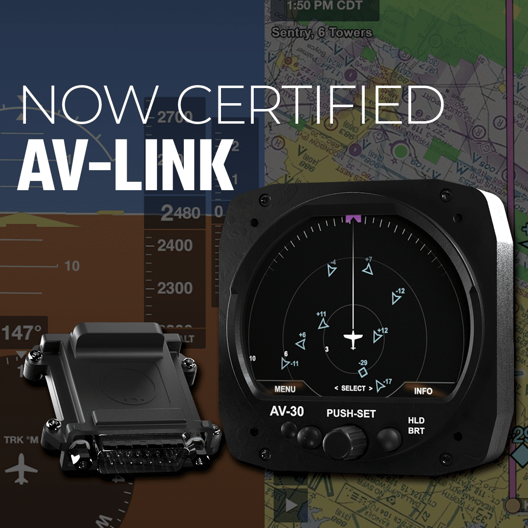
Dawn Zoldi: Staying on the topic of general aviation (GA), let’s discuss AV-Link PMA, which the FAA just approved. What is it?
Brit Wanick: We have a certified primary attitude indicator and directional gyro cockpit display, known as the AV-30-C, which has a supplemental type certificate (STC) for use in GA aircraft. This multifunction device performs various tasks. In experimental aircraft, such as homebuilt planes, where traditional certification is absent, the AV-30-E, the non-certified version, can be paired with an AV-Link, a Wi-Fi enabled device, to receive ADS-B traffic from devices like Sentry by ForeFlight. Through the recent AV-Link PMA approval by the FAA, the AV-30-C, the certified version, can now display this traffic on a 3-inch cockpit display without necessitating a complete panel overhaul. So that provides the ability for the display of non-certified traffic on certified avionics. And that’s a first! We’re really excited about being able to bring that capability to our customers flying certified aircraft. The AV-30, both versions, AV-Link pairing also enables wireless update capabilities, ensuring continued enhancement and longevity of the instrument’s performance. This advancement not only enriches the pilot’s cockpit experience but also signifies a shift toward integrating digital functionalities into older general aviation aircraft navigating in an increasingly crowded airspace.
Dawn Zoldi: Will drones or the air taxis of the future interact with the GA cockpit display through AV-Link?
Brit Wanick: The AV-Link PMA, AV-30 pairing, with its display capabilities, enhances our ability to show flying objects transmitting ADS-B, and that could include some drones and presumably all air taxis.
Dawn Zoldi: Why is this kind of situational awareness so important?
Brit Wanick: While it’s relatively easy to spot something out the window, challenges arise when visibility is hindered by factors like darkness, clouds or size. If we network together everything that flies, and I know where every node of that network is, it becomes easier for me to avoid them. It’s when I don’t know where they are that it becomes difficult. And when we establish right away rules, we can arrive at what’s best for the operational conditions and create both a regulatory environment and technological and operational environment that is best suited for both crewed aviation and uncrewed aviation. Remote pilots, unpiloted autonomous vehicles, all that starts to become possible when we have that correct infrastructure in place. That’s what we are here to do. As so well stated by Christian Ramsey, our Chief Commercial Officer, we are in the business of “connecting everything that flies.”
Dawn Zoldi: You also make ADS-B products. Talk about those.
Brit Wanick: The ping brand essentially is our evolution of ADS-B Out. Small Size, Weight and Power (SWaP) is one of our superpowers. We tackle significant technological challenges while ensuring compatibility with the aircraft’s mission parameters. If we came out with a typically-sized and heavy transponder and said, “Yeah, we’re going to drop this on a 5-kilogram drone,” you’d take away all the available payload. We had to approach the problem from a different perspective. Our team, led by experienced technologists like Paul Beard, our Chief Technical Officer, has extensive expertise in Radio Frequency (RF) technologies. He and his team engineer lightweight ADS-B devices, both for transmission and reception. Broadcasting the position is only half the equation; knowing the precise location is equally crucial. We’ve invested a lot in developing high-integrity, high-accuracy Global Positioning System (GPS) solutions, such as the truFYX with FAA Technical Standard Orders (TSO) C145e certification. This ensures the accuracy of the information broadcast by our devices. Creating that holistic solution set helps us in the marketplace and give someone the means to build it into their aircraft to accomplish their mission.
Dawn Zoldi: Ground-based surveillance and hardware can also assist with situational awareness. Tell us about Casia G.
Brit Wanick: We’ve discussed cooperative aircraft equipped with ADS-B, but not all aircraft are equipped with this technology. There are other flying vehicles or systems that may not have ADS-B or be electronically conspicuous. Enter Casia G, acquired through Iris Automation in October 2023. This computer vision system optically detects and classifies objects in the sky, specifically targeting non-cooperative aircraft. It can also receive ADS-B signals. Integrating these capabilities allows operators, whether conducting pipeline inspections, citywide deliveries or assisting a police department’s DFR program, to effectively manage BVLOS operations. This is critical for evaluating safety and risk assessments and enables operators to obtain FAA approval for their operations.
Dawn Zoldi: Do you incorporate other satellites or methods for locational data in your ecosystem?
Brit Wanick: We’re very much looking into a variety of different ways to come up with complementary Precision Navigation and Timing (C-PNT). In the U.S., we benefit from significant ground infrastructure and can employ tools such as multilateration. With devices deployed across numerous aircraft and ground locations, we’re adept at developing supplementary methods to validate aircraft positioning, including through GPS data. In areas lacking ground infrastructure, we examine low earth orbit (LEO) satellite constellations, utilizing their signals and time differentials for navigation. We don’t have a product today, but it’s part of what we’re trying to deliver into the ecosystem. It all ties together. You need to know where you are and where you’re going as well as to have control over that aircraft over a long range. Currently, our priority lies in establishing redundancy for command and control (C2) systems for operational continuity in the event of system failures. Our assured C2 solutions, such as Skyline and muLTElink technology are optimized for BVLOS operations and help to mitigate risks associated with potential GPS signal loss.
Dawn Zoldi: In the meantime, though, uAvionix has partnered with several satellite communications companies as part of your overall C2 ecosystem. Can you tell us about that?
Brit Wanick: Depending on where you’re flying, you may have different needs better met by Viasat or another company like Iridium, each has unique satellite communication services. We’re not tied to one particular service. For example, we’ve been working with Viasat for a while now. They have a unique approach with their recent merger with Inmarsat, providing access to different constellations—Geostationary Earth Orbit (GEO), Medium Earth Orbit (MEO) and LEO. Partnering with major providers helps us meet our customer’s needs and gives us valuable insights into what works best in different situations. As we continue to develop ubiquitous satellite communication and BVLOS infrastructure, our expertise in navigating diverse partner offerings remains a cornerstone. The knowledge level that we can bring to our customers to help them steer towards an appropriate solution across all those partners is one of our core competencies. This expertise has proven to help accelerate BVLOS initiatives, such as those in test sites like the Choctaw Nation of Oklahoma and facilitates quicker program advancement for our customers.
Dawn Zoldi: Speaking of C2, what is the approval status of your muLTElink system?
Brit Wanick: muLTElink is in itself a dual-frequency, dual link radio providing both frequency and path diversity and connectivity to our SkyLine assured command and control (C2) solution. The multiple link airborne radio system, combines a DO-377A Link Executive Manager (LEM) with integrated LTE and C-Band C2 radios plus support for an external ISM C2 radio. A transparent RS232 serial interface is provided for connection to an autopilot such as our George autopilot. muLTElink streamlines platform integration by automatically registering an aircraft with SkyLine Cloud Managed BVLOS service.
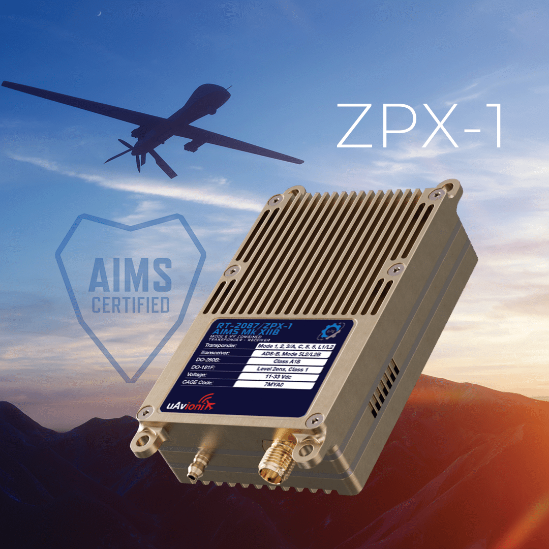
Dawn Zoldi: On the military side, you’ve got the new ZPX-1 combined transponder receiver. Tell us about that.
Brit Wanick: The ZPX-1 represents an evolution of our initial Mode 5 Identification Friend or Foe (IFF) transponder, the ZPX. Designed to meet the specific requirements of the future tactical UAS program within the Army, the ZPX-1 recently received AIMS certification, making it the sole device tailored to these needs. It benefits both Textron Aviation and Griffon Aerospace who are supporting the program. This unique device integrates transponder and receiver functionalities for ADS-B and Mode 5, offering a military-grade means of aircraft identification. It supports new modes such as Level 2 and Level 2 broadcast under Mode 5 to enhance battlespace awareness for both crewed and uncrewed aircraft. Essential for programs in Defense, this compact yet powerful device ensures payload preservation, operational mission efficacy and power efficiency. We’ve extended the ZPX line with other options such as the receiver-only ZPR, and help companies with crypto testing, by providing emulators which would otherwise be costly for them. We provide these capabilities for testing ahead of deployment to speed up their approvals and production.
Dawn Zoldi: As we wrap up, can you tell folks how they can get in touch with you?
Brit Wanick: We were just at the Energy Drone & Robotics Summit. In July, we’ll be at AirVenture in Oshkosh, the largest general aviation show where both uncrewed and crewed operators will be present. Later this year, we’ll be at Commercial UAV. Also, feel free to visit us at https://uavionix.com/ or email us at squawk@uavionix.com. We’re always eager for feedback and to engage with the aviation community to ensure we’re serving you well. We’re pilots ourselves, both in general aviation and UAS and we’re committed to making things better for everyone. We look forward to chatting with you!